|
SUKATANI FIELD
WEST JAVA, REPUBLIC OF INDONESIA
EXECUTIVE SUMMARY
The Sukatani Field, West Java, Indonesia has produced over 1BCF during the period August 2001 to August 2002, and was producing more than 1.5MMCFGPD when a mechanical problem in the producing well necessitated abandoning the producing zone. Other probable gas zones exist.
Tradewinds Oil and Gas International, Ltd., through its wholly owned subsidiaries, PT. Radiant Energi Sukatani and Gulfstream Resources Sukatani Limited, collectively Tradewinds, is seeking a party to further evaluate and develop the Field, under the Trade Terms described in Attachment 1.
A significant amplitude anomaly exists in zones 13 and 14 to the northeast of the STN #1 well. As no anomaly exists at the STN #1 well, even though it produced over 1 BCF, it is encouraging for future development.
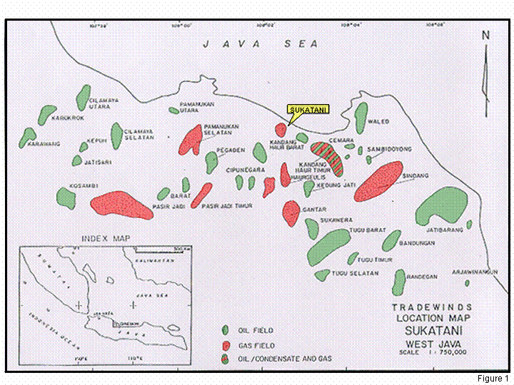
LOCATION
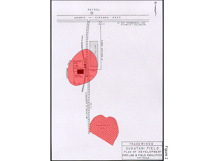
The Sukatani structure is located 7 kms. South of Patrol village along the Jakarta to Cirebon main highway and is approximately 200 metres off the paved Patrol to Haurgeulis side road, onshore Northwest Java (Figure 1 and 2).
SUKATANI FIELD HISTORY
A Technical Assistance Contract (TAC) between Pertamina and PT. Radiant Engergi for the Sukatani Field was signed on June 16, 1995 for a 20 year contract term. The TAC terms are summarized in Attachment 2.
The Sukatan-1 well was spudded by Pertamina in September 1982 and drilled to a total depth of 2,554 metres into the Jatibarang volcanic. A total of five DST’s were performed. One DST in the Talang Akar Formation and three DST’s in the Batu Raja Limestone flowed gas with high CO2 content, ranging from 77% to 82%, with minor amounts of condensate. The only DST within the Upper Cibulakan, Zone-14 A Sand flowed 11.7 MMCFGPD and 144.3 BCPD with 1.98% CO2 content. Other probable Cibulakan gas bearing zones were not tested however, they calculate productive. The well was suspended by Pertamina as a gas well in November 1982.
The Sukatan-1 well was completed with wellhead equipment and suspended by PT. Radian Energi Sukatani as a gas well in 1997. In December 2000, Tradewinds Oil and Gas International, Ltd. Acquired all of the stock and assets of PT Radiant Energi Sukatani. The company then completed construction of a 4 km pipeline to transport gas to a transmission line and placed the well on production in August 2001. The well produced a cumulative 1.03 BCFG in the ensuing year from the Cibulakan 14 A Zone. Unfortunately, the cement sheath around the production string was ineffective and the lowest zone, with high CO2 content, began to feed into the upper producing zone perforations, in August 2002, requiring abandonment of the producing zone and cementing off the lower zone. Some unproduced Cibulakan zone reserves remain in the 14 A zone, as well as interpreted gas productive zones, that remain untested, both above and below the 14 A reservoir.
REGIONAL GEOLOGY
The Sukatani Field is located in the Northwest Java Basin, one of many back-arc basins, or foreland basins, developed behind the volcanic arc. The basin was formed in response to the collision of the Sunda plate with the Indian-Australian plate during Early Eocene to Oligocene time. Southward tilting of the Sunda plate was probably the result of the oceanic plate subducting beneath it. The present subduction zone lies beneath the Indian Ocean parallel to the south coast of Java. Plate tectonic movements controlled both the structural development and the sedimentation in the Northwest Java basin. The regional structural trends are oriented east-west, parallel to the Java subduction zone and are the result of north-south compression stress in Middle Miocene and Pliocene time. East-west tensional stress has resulted in pronounced north-south trending block faultings. These block faultings are responsible for the development of the Northwest Java basin and its numerous sub-basins and basement sub-basin, Pamanukan High arid Jatibarang sub-basin (Figure 3). The Sukatani structure is located on the Pamanukan High uplift.
HYDROCARBON GENERATION AND MIGRATION
The Talang Akar sediments in the Northwest Java basin is the best potential source rock. The rich liptinitic kerogen in non-marine Talang Akar sediments in the onshore Northwest Java area are the effective source rock (Soulisa and FX Suanto, 1979). The oil window is estimated to be at a depth between 6,000 and 7,200 feet (2,000 and 2,400 metres).
The Sukatani structure is located on the Pamanukan High and was probably sourced from nearby “local low” or sub-basin areas such as Pasir Putih and Jatbarang sub-basin (Figure 3). The bounding faults, which define the north-south trending Pamanukan High, may have acted as pathways for hydrocarbon migrating from the Basinal generation areas. It is observed that most of known hydrocarbons in the Northwest Java sub-basins are associated with faults of a similar nature (Gordon, 1985).
NEARBY PRODUCTION
In onshore Northwest Java there are several producing Oil and Gas Condensate fields surrounding the Sukatani Field (Figure 1) such as:
Kandang Haur Barat Field, with initial reserves of 9.31 MMBO.
Kandang Haur Timur and Pagaden Oil and Gas Fields, with initial reserves of 9.80 MMBO / 24.8 BCFG and 5.72 MMBO 147.2 ECPG respectively.
Pamanukan, Haurgeulis and Gantar Gas Fields with initial reserves of 18.7, 38.0 and 241.8 BCFG of associated and nonassociated gas respectively.
The oil and gas condensate zones are within the Upper and Lower Cibulakan as well as the Parigi Formations.
TECHNICAL DATA
The data in PT. Radiant’s office are Xerox copies with good to moderate quality reproductions. Data is complete with a number of available reports. No wireline log tapes are available. Seismic tapes are available for some of the lines. Mudlog and cement bond logs may be available.
|